

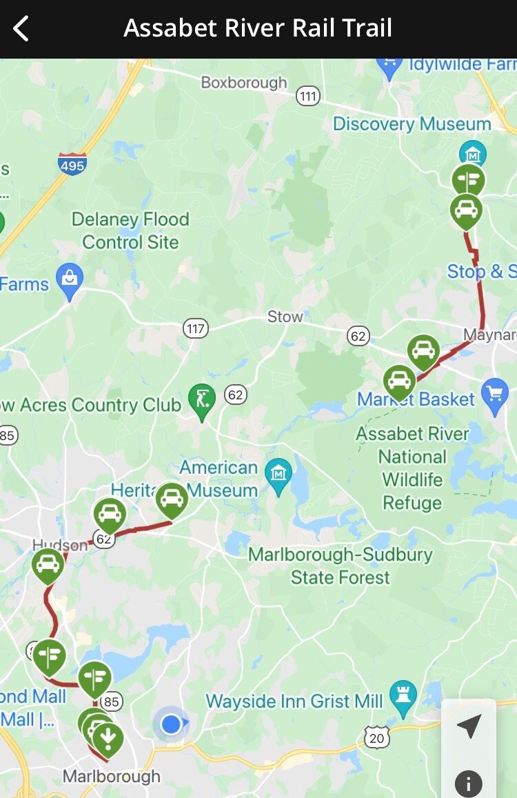
The Assebet River Rail-Trail map, from Marlborough to Acton.
And into the forest I go to lose my mind and find my soul.
-John Muir
It occurs to me that, although I’ve written a lot about it, I’ve never described the Assebet River Rail Trail in its entirety. It is Waldo’s and my favorite walk through nature, and it runs from Acton to Marlborough. It follows, more or less, the railroad bed of the Marlborough Branch of the Fitchburg Railroad, about a fourteen-mile trek in toto. Its northern terminus is next to the South Acton MBTA train station, a place where the train to Boston still runs. The Southern-most end is in Marlborough, across the street from where Waldo and I park our car when we go for our walks. In the middle there is a gap where you have to take to the city streets if you want to walk the full distance – something we have never done. The southern portion of the trail is five-and-a-quarter-miles long and the northern section runs for three and a half miles. The gap, of about five-and-a-quarter miles, is supposed to be developed at some point in the future, but at this time, one is forced to take a wandering route along the sides of roads with traffic. Waldo and I usually stay on the first three miles of the southern portion, although we have walked the full five-and-quarter miles and also the three-and-a-half miles of the northern part.
Our portion of the trail is paved, with a painted intermittent yellow line running in a regular staccato fashion down its middle, and follows a serpentine route through woods and meadow. Houses are close by in the beginning, but there are bushes, weeds, vines, and trees that separate us from our neighbors. In the spring, summer and early fall, these plants create a green wall, punctuated with flowers of various colors, insulating anyone on the trail from the enveloping city. It’s easy to ignore the sounds of cars, lawn mowers and the general throb of urban life and feel that one is strolling through a tunnel of nature, far from the madding crowd. In the winter, this wall becomes a hodge-podge of intertwined sticks of various sizes — a godsend for Waldo. There are many different species of plants here, the undergrowth in places dominated by Japanese knotweed, and I’m sure that they all put root to soil through arbitrary accident (with one exception, a small Covid-garden alongside the trail), rather than by the intentional hand of man. The number of different species is copious and bears testimony to the fecundity of the natural world, left to its own designs.
After a quarter of a mile, the trail crosses Ash Street. Here the nearest houses retreat from the path — it’s as if human habitation is slowly withdrawing from where we walk. Oaks, maples, black walnut trees, along with trees of heaven, sumac, white pine and others, begin to dominate. The undergrowth remains alongside the tarmac where it can still get sunlight, but further away from the trail, the trees dominate and the weeds and bushes become more anemic, then disappear. After three-eighths of a mile, we cross Hudson Street and, soon after, forest wafts off into the distance as far as you can see, which is limited by the density of the greenery during most of the year. In the winter, once the leaves are gone, you can vaguely see in the distance, through twig and branch, the surrounding city-scape, but the rest of the year the insulation is nearly complete.
After another three-eighths of a mile, we cross Boston Scientific Way, the entryway to a large corporate entity of the same name, and about one mile from our starting point. Just past the street is a large open meadow that slopes gently down to Fort Meadow Reservoir. The meadow is a landfill and has several pipes, two or three inches in diameter, stuck in the ground and topped with a curve that points the opening downward. These are vents for any methane that may be produced underground, so it doesn’t collect and cause problems. At the bottom of the hill is a two-laned highway, Route 62, that borders the water. There are two causeways that cross the reservoir and the wooded hill on the opposite shore is packed with several large houses. Walking along, looking across the landfill and the watery expanse, one could almost imagine that they were seeing a quaint Maine town on the Atlantic coast on a calm day, instead of a small piece of Marlborough alongside a reservoir. It is particularly picturesque in autumn when it is bathed in the technicolor display of fall.
Soon after, some one-and-a-half miles from our starting point, we parallel Sasseville Way, cross Fitchburg Street and then follow close by Crowley Drive. On our right is the fenced-in athletic field of the Assabet Valley Regional Technical High School. Signs clearly state that it is verboten for the public to enter the grassy expanse, which is a real shame. Alas, I would love to take Waldo off leash and just let him run at will in all that protected space. Just past the field, the path continues through thick forest, on both sides, down to a tunnel that passes under the Route Eighty-Five Connector that is the end of Interstate Two-Ninety and the boundary between Marlborough and Hudson. From there, now having gone more than two miles, the trail continues on in deep woods a little more than another mile to Washington Street, a busy thoroughfare. Waldo and I turn around and head back just before then, a little more than three miles from our car, to complete our daily walk.
Waldo and I, we love this trail.
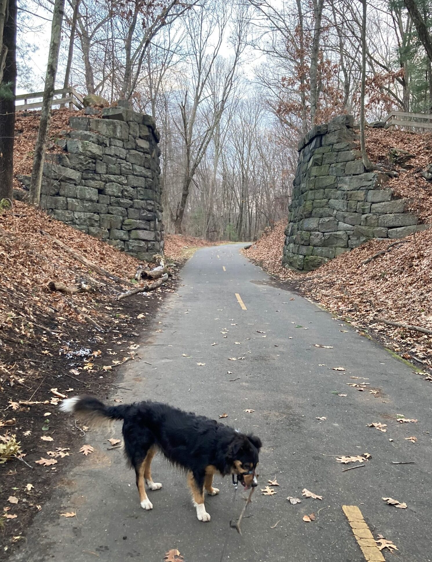
Brigham’s Bridge, a farm bridge built with no mortar.